Kyoto Startup Digest 2018 is documenting the Kyoto startup scene through a series of articles and videos by the following members of the KYOTO Design Lab and interns from the University of Texas.
Stroll Through Stories on an Interactive Map Platform
While most of us see maps as simple tools to navigate the world around us, maps are also forms of expression providing different perspectives on the world they portray. A road map is different from a tourist map or a historical map that can even take you back in time. While there is only one world, there are many maps that can help you discover new places and stories in familiar cities, and Stroly makes it easy for you.
Stroly is an interactive map platform that provides opportunities for users to submit their own maps that can be shared with anyone online. When a user uploads a map (even a hand-drawn one), Stroly’s special map overlay technology matches it to an accurate GPS map regardless of the disproportionate scale and orientation. With Stroly, GPS positioning can be shown on any kind of designed maps in any form, so that creators can tell their local stories to the those with the app.
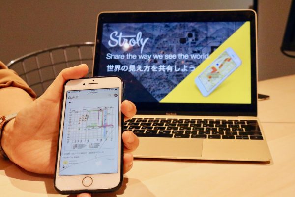
Stroly map demonstration
With the Stroly editor, users can place landmarks and points of interest along with comments, links, and pictures to make the maps richer. Uploaded maps are given an ID, titled, and tagged to make them easily accessible and searchable. Stroly maps are easy to use like any other map application, and users can switch between the standard and illustrated maps. These editing features allow creators to express their personal style and support explorers in exchanging their views.
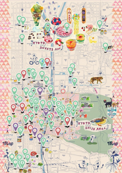
Kyoto Sweets Map
Stroly not only provides a free, creative content sharing platform, but it works with clients to create maps on its platform for regional branding and tourism promotion. Whether it be for travel agencies, amusement parks, transportation companies, or any other business, Stroly will help design and produce maps for their needs.
Stroly can provide a QR code that opens the maps via direct link onto Stroly’s website where they are easily navigated. This feature helps businesses reach out to more people with new, easy to use interactive maps. Stroly can also collect and provide data on map usage for analytics which businesses can use to evaluate their promotions. One collaboration Stroly has established is with the city of Kyoto. You can find Stroly map QR codes on several outdoor analog maps around the City that will open a pocket version of the map in the palm of your hand.
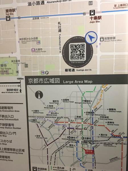
Stroly QR code on a map outside Kujo Station
The Stroly team was originally a subsidiary company of ATR named ATR Creative, working on the service before spinning out as an independent company and beginning their startup journey. Management buyout was conducted in 2016, and a Series A fundraising worth 1.4 million USD in May 2017 helped the company open its central office in Kyoto with another location in Tokyo.
Having just released the beta version of the international website in June 2018, Stroly plans to expand their platform and user base on a global scale, encouraging more people to express and experience their surroundings in new ways. Helping find new discoveries and making maps a more interactive experience, Stroly is providing the platform for people to express what cannot be expressed on basic maps.
Interview
How is Stroly different from other navigation services?
Machi: We are a location service and not a navigation service. Our service is a platform that brings illustrated maps online. These maps exist so they can express what does not appear on google maps or more traditional maps. Maps that are handed out in brochures or online with PDFs are not interactive. Stroly allows users to position illustrative maps over pre existing maps, then the positions of landmarks are correlated so that you can use it with GPS positioning. You can select landmarks and add the context of these places with images or text as source of information for those using your map. As soon as you publish your map it is ready to use with a URL or QR code, both of which can be used to direct your users to the map online. You don’t have to download any app, it is a web service made available for free.
What was the initial idea when you started this company?
Machi: We found out about this idea in a theme park when we were asked to make a guide system for visitors. We found out that if you use a regular map, you would find roads for trucks that were not supposed to be there in a regular map. So we decided we would use the maps handed out by the parks over google maps. We successfully made a demo version and figured that these design maps are universal, we thought it could be used in many places, not just one theme park. So we made a platform where we can keep uploading lots of maps.
What collaborations is Stroly doing with other industries? Do you have clients?
Machi: Our service is great for regional branding and marketing in general, and we have clients who use our service for their businesses. For example, train companies have to advertise their area so more people use their trains. What we do is gather data for these clients based on their maps. In Kyoto City, every single analog map has a Stroly QR code. We make the data of engagements available to them so they know what to do next, such as promotions. We also consult with our clients, and we suggest them to do certain things so that they can expand the use of their maps.
Do you see more activity coming from the users side or from clients wanting your services?
Machi: Our devotement is on maps and the way we can add to them, but how we show it to corporate or how we share it to the public, it looks different, but it’s based on the same platform. We now have two different teams for the users and clients. When we say users, they are primarily those who submit their maps for their services. At the beginning, we thought people more likely to submit maps would be those doing it as a hobby, but it turned out that there are more serious people using this, like people running events or businesses wanting to promote their areas. Our users on the free platform are actually small to medium sized companies and communities.
Does company have any plans to scale up?
Machi: We are working on community based scaling. We’re running workshops to encourage people to make and submit maps. We make it so that they are available to communities all over Japan and the world. The workshops helps participants find out about their local goodness so that they can express what is great about their city.
Why Kyoto, what makes its city unique?
Machi: Our domain is travel and tourism as well as regional branding. We wanted to be in a place where there are many tourists and Kyoto has more tourists than other places. We prefer our headquarter being in Kyoto because it is not saturated with too much information and can concentrate on the core concept of our platform. The good thing about being here is that we can work with people in the field and can also speak with tourists directly. There are also lots of universities so we can invite students to run workshops with us and participate in our events. There are lots of creators who graduate from schools in Kyoto so there are quite a few people who can actually work with us, it’s a good circle and community for us here.
Check out Stroly here
KSD 2018
00|Introduction
01|Nota Inc.
02|Makers Boot Camp
03|Hacarus
04|Kyoto Startup Summer School
05|Ship&co.
06|Atmoph
07|Kyoto Makers Garage
08|GLM
09|ZenVita
10|Stroly
Kyoto Startup Digest 2018 is documenting the Kyoto startup scene through a series of articles and videos by the following members of the KYOTO Design Lab and interns from the University of Texas.
Stroll Through Stories on an Interactive Map Platform
While most of us see maps as simple tools to navigate the world around us, maps are also forms of expression providing different perspectives on the world they portray. A road map is different from a tourist map or a historical map that can even take you back in time. While there is only one world, there are many maps that can help you discover new places and stories in familiar cities, and Stroly makes it easy for you.
Stroly is an interactive map platform that provides opportunities for users to submit their own maps that can be shared with anyone online. When a user uploads a map (even a hand-drawn one), Stroly’s special map overlay technology matches it to an accurate GPS map regardless of the disproportionate scale and orientation. With Stroly, GPS positioning can be shown on any kind of designed maps in any form, so that creators can tell their local stories to the those with the app.
Stroly map demonstration
With the Stroly editor, users can place landmarks and points of interest along with comments, links, and pictures to make the maps richer. Uploaded maps are given an ID, titled, and tagged to make them easily accessible and searchable. Stroly maps are easy to use like any other map application, and users can switch between the standard and illustrated maps. These editing features allow creators to express their personal style and support explorers in exchanging their views.
Kyoto Sweets Map
Stroly not only provides a free, creative content sharing platform, but it works with clients to create maps on its platform for regional branding and tourism promotion. Whether it be for travel agencies, amusement parks, transportation companies, or any other business, Stroly will help design and produce maps for their needs.
Stroly can provide a QR code that opens the maps via direct link onto Stroly’s website where they are easily navigated. This feature helps businesses reach out to more people with new, easy to use interactive maps. Stroly can also collect and provide data on map usage for analytics which businesses can use to evaluate their promotions. One collaboration Stroly has established is with the city of Kyoto. You can find Stroly map QR codes on several outdoor analog maps around the City that will open a pocket version of the map in the palm of your hand.
Stroly QR code on a map outside Kujo Station
The Stroly team was originally a subsidiary company of ATR named ATR Creative, working on the service before spinning out as an independent company and beginning their startup journey. Management buyout was conducted in 2016, and a Series A fundraising worth 1.4 million USD in May 2017 helped the company open its central office in Kyoto with another location in Tokyo.
Having just released the beta version of the international website in June 2018, Stroly plans to expand their platform and user base on a global scale, encouraging more people to express and experience their surroundings in new ways. Helping find new discoveries and making maps a more interactive experience, Stroly is providing the platform for people to express what cannot be expressed on basic maps.
Interview
How is Stroly different from other navigation services?
Machi: We are a location service and not a navigation service. Our service is a platform that brings illustrated maps online. These maps exist so they can express what does not appear on google maps or more traditional maps. Maps that are handed out in brochures or online with PDFs are not interactive. Stroly allows users to position illustrative maps over pre existing maps, then the positions of landmarks are correlated so that you can use it with GPS positioning. You can select landmarks and add the context of these places with images or text as source of information for those using your map. As soon as you publish your map it is ready to use with a URL or QR code, both of which can be used to direct your users to the map online. You don’t have to download any app, it is a web service made available for free.
What was the initial idea when you started this company?
Machi: We found out about this idea in a theme park when we were asked to make a guide system for visitors. We found out that if you use a regular map, you would find roads for trucks that were not supposed to be there in a regular map. So we decided we would use the maps handed out by the parks over google maps. We successfully made a demo version and figured that these design maps are universal, we thought it could be used in many places, not just one theme park. So we made a platform where we can keep uploading lots of maps.
What collaborations is Stroly doing with other industries? Do you have clients?
Machi: Our service is great for regional branding and marketing in general, and we have clients who use our service for their businesses. For example, train companies have to advertise their area so more people use their trains. What we do is gather data for these clients based on their maps. In Kyoto City, every single analog map has a Stroly QR code. We make the data of engagements available to them so they know what to do next, such as promotions. We also consult with our clients, and we suggest them to do certain things so that they can expand the use of their maps.
Do you see more activity coming from the users side or from clients wanting your services?
Machi: Our devotement is on maps and the way we can add to them, but how we show it to corporate or how we share it to the public, it looks different, but it’s based on the same platform. We now have two different teams for the users and clients. When we say users, they are primarily those who submit their maps for their services. At the beginning, we thought people more likely to submit maps would be those doing it as a hobby, but it turned out that there are more serious people using this, like people running events or businesses wanting to promote their areas. Our users on the free platform are actually small to medium sized companies and communities.
Does company have any plans to scale up?
Machi: We are working on community based scaling. We’re running workshops to encourage people to make and submit maps. We make it so that they are available to communities all over Japan and the world. The workshops helps participants find out about their local goodness so that they can express what is great about their city.
Why Kyoto, what makes its city unique?
Machi: Our domain is travel and tourism as well as regional branding. We wanted to be in a place where there are many tourists and Kyoto has more tourists than other places. We prefer our headquarter being in Kyoto because it is not saturated with too much information and can concentrate on the core concept of our platform. The good thing about being here is that we can work with people in the field and can also speak with tourists directly. There are also lots of universities so we can invite students to run workshops with us and participate in our events. There are lots of creators who graduate from schools in Kyoto so there are quite a few people who can actually work with us, it’s a good circle and community for us here.
Check out Stroly here
KSD 2018
00|Introduction
01|Nota Inc.
02|Makers Boot Camp
03|Hacarus
04|Kyoto Startup Summer School
05|Ship&co.
06|Atmoph
07|Kyoto Makers Garage
08|GLM
09|ZenVita
10|Stroly